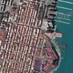
Mira Solutions Completes Color Ortho Project of US Metropolitan AreasMira Solutions recently completed 40,000 square miles of color digital orthophotography covering various metropolitan areas throughout the United States. Working directly for Digital Globe, Mira Solutions managed the entire project including the aerial acquisition utilizing digital mapping cameras along with ABGPS and IMU. Mira Solutions collected ground control points, performed the aerotriangulation and developed the final color orthos at 1’ pixel resolution. Some of the project areas included: Salt Lake City, UT; Reno – Tahoe, NV; Santa Barbara, CA; Sacramento, CA; Albany, Buffalo, & Rochester, NY. |
|
|
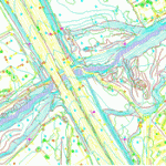
Caltrans Topographic & Planimetric MappingUnder an on-going contract with Caltrans, Mira Solutions has compiled 1′ contours and planimetry at 1′ = 50′ scale covering various sections of highway corridors in northern and southern California. |
|
|
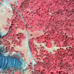
Gualala Redwoods Orthophotography ProjectMira Solutions recently completed natural color and color infrared orthophotography at 1’ pixel resolution covering the entire Gualala Redwoods along the Mendocino coast. From approximately 472 digital aerial images acquired with a large format digital aerial mapping camera, Mira Solutions performed the aerotriangulation utilizing AGPS/IMU data with supplemental ground control; compiled new DTM; then developed both color and CIR orthos. Seam lines were carefully executed to achieve minimum tree lean in this densely forested area. |
|
|